
When you drive next to Traunsee you'll see in front of Erlakogel, nicknamed sleeping Greek woman because the shape reminded someone of a Greek woman, some rock spires, the Gasseltürme. A year ago we were passing it and a friend told me he wants to go up there, so we started research, at first needed to find the name and then some reports, this was our biggest help. Although it is not high at all, it involves proper alpine climbing /scrambling in the high second grade more than once and is always properly exposed. We took a rope and such equipment but used it only for abseiling. It can be also used for going up as there are anchors every 25 m approximately, going down also working without rope, but it made sense using it as we had it and as it was less annoying and dangerous.
One highlight was definitely the peak book, first entry from 1969, still not full, and we were the third entry in 2022 (June 2022), so it is definitely a hardly climbing adventure.
Transportation
We took the car to the parking lot in Rindbach, Ebensee, per day it is 6 euros, also possible to stay overnight with toilets and a small kiosk for 20 euros, direct access to the Traunsee lake is pretty amazing, although it's always quite windy there.
By train, you go to Ebensee, from any of the two stations it is just a two-kilometre hike to the start of the hike, so no big deal, in case there is waiting time for the train back, there are worse options than spending time at a lake.

Dachstein glacier in the back.
Hike
Starting with just following the signs all the way to Erlakogel the whole time, passing the Spitzelstein Alm with insanely cute baby highland cattle, with serpentines cutting the forest road several times and once the sign is showing to the right to Erlakogel via a short ladder you need to keep on the forest road till the very end, it's quite logical as you'll always face the Gasseltürme.


At the end of the road you need to get to the fact of the spires, we missed the trail and went a bit more down, worked as well, but the better path has slight traces of steps and a cairn/Steinmanderl (piled rocks to show an unmarked trail) visible, it's pretty close to the rock and to the right when facing the towers.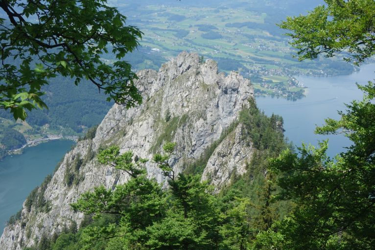

Keeping up high to the right here, at the rock between the rock face to the right and the green tree in the middle, there is a cairn for orientation.
After walking through the forest, you'll see a remembrance plaque for 3 local climbers perished in 1932.
If you climb with rope, now it's time to use it, we just put on our harnesses as we were undecided if we want to use the rope. A narrow stripe of grass you follow very exposed around 15-20 m till you think you do not want to continue there and with a chimney like start in the beginning to the right.

From now on the climbing starts, many parts in second grade and always with the wall going several hundreds metres down underneath you. The rock was very solid and provided proper grip for the hands, but still be cautious as some might be loose and the grass you sometimes stand on is not too stable. The route is quite logical, anchors and slings occasionally show you that you're still correct. The trail often changes from rock climbing to walking through mountain pines.
Solid rock climbing skills and especially no afraid of heights are required the whole time.

Via a long, rather flat, ledge you walk a bit to the right, it looks slippery but had solid holds on the right and was decent for finding hold with your feet. Then you're on the small ridge, to the left is the aim: the Mittelturm, middle tower, again solid rock climbing in the second grade, was a good rock but on both sides it's going pretty much down. After you succeeded with this, you're on the peak and will see the box with the summit book.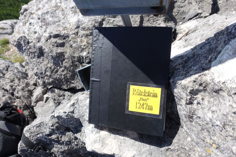
After a short break on the rather tiny ridge, getting all abseil equipment on the harness and starting to go to town, the first parts we just climbed down, was pretty okay and faster than with rope. After the Platten! Part we abseiled 3 times till the bottom, also possible to down climb, up to your preferences. We had a 50 m single rope, worked okay, but better would be a 60 m rope. Just following the ascent part and then walk back to the forest road, the trail you came from.

Car till the peak took us 2.5h, back down to the road 1h (including breaks).
Now the adventure is over, and you can return to the car or add some more fun. Easiest option is just on the normal path up to the Erlakogel peak, but we decided to avoid walking all the way back to the crossroad and just take a direct one through high grass, always up and the peak cross gives some help for orientation, we decided then to go to some peak bit to the left of the main one with the cross, nice II grade climbing on solid rock and then crossing via the ridge to the cross, was great fun to do but also takes some orientation skills as nothing is marked and there were no steps visible whatsoever.
Upper: on the right there is the cross of the Erlakogel, we ascended somewhere via the right rock and scrambled via the ridge to the cross.
Down: you can nicely see the forest path, at the place where the forest aisle is joining with the road we just went up via the high grass (be aware of ticks!), we orientated towards the right side and the rocky peak to not accidentally end up on the steep wall.
Going down just via the well-marked main path back to the car and now for a deserved cooling down into the lake.